CelLink™
Software Tool for Planning of Point-to-Point, Microwave Links
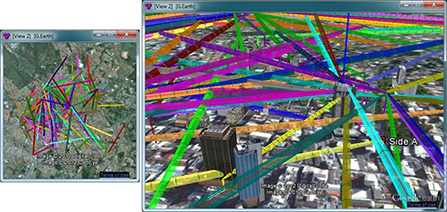 CelPlanner™ (Network) / CelLink is a tool for planning and designing fixed, point-to-point radio systems and meeting ITU-R (former CCIR) quality standards. From single links to national networks, our tools provide a very valuable resource for wireless systems designers. An entire network can be entered in a database that will display the point-to-point network as an overlay on area maps, which are provided with the software. CelPlanner™ (Network) / CelLink is a tool for planning and designing fixed, point-to-point radio systems and meeting ITU-R (former CCIR) quality standards. From single links to national networks, our tools provide a very valuable resource for wireless systems designers. An entire network can be entered in a database that will display the point-to-point network as an overlay on area maps, which are provided with the software.
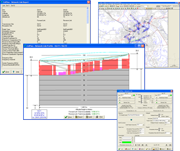
Single point-to-point links can be designed considering terrain, clutter, tower heights, and multiple-knife diffraction. CelLink can display obstruction in Fresnel zones as well as the path loss. Tower height requirements are automatically displayed for each configuration. A database of all other existing links can be assembled on a regional or national basis.
For lower frequencies, CelLink uses the Picquenard method (also known as the Deygout model) to calculate the attenuation caused by diffraction. After the diffraction situation is determined, a user can analyze other parameters that determine the unavailability objectives established to meet the ITU-R quality standards of this link. For frequencies over 10 GHz, CelLink can calculate rain attenuation for each link and then analyze additional parameters.
The software utilizes link data, such as topography, morphology, images, equipment specifications, and climatic features of the region, to provide the results of performance of the link and compare results with the requirements established by ITU-R.
 Users can consider basic types of channel arrangements found in radio transmission systems: co-polar, cross-polar, and co-channel. For each of these cases, CelLink determines the degradation caused by the interference on a useful channel. Finally, in performance calculations, users can include improvement factors due to the existence of counter measurement devices in the system, such as equalizers, coders, and diversities (space, frequency, and space and frequency). Users can consider basic types of channel arrangements found in radio transmission systems: co-polar, cross-polar, and co-channel. For each of these cases, CelLink determines the degradation caused by the interference on a useful channel. Finally, in performance calculations, users can include improvement factors due to the existence of counter measurement devices in the system, such as equalizers, coders, and diversities (space, frequency, and space and frequency).
The following features are available:
- Integrated backhaul planning & link analysis
- Complete path analysis
- Multiple links consideration
- Wireline and wireless connections
- Automatic terrain profile, climate and rain factor calculations
- Full link and network interference analysis including calculation of degradation for each interfering link
|